- India
- International
Friday, Apr 26, 2024
Journalism of Courage
 Despite the monsoon's early arrival on May 29 over Kerala, rainfall has been abysmally poor over most regions where the onset has been declared. The rainfall deficiency for the season until June 17 is as high as 60% in Kerala and Maharashtra. (File)
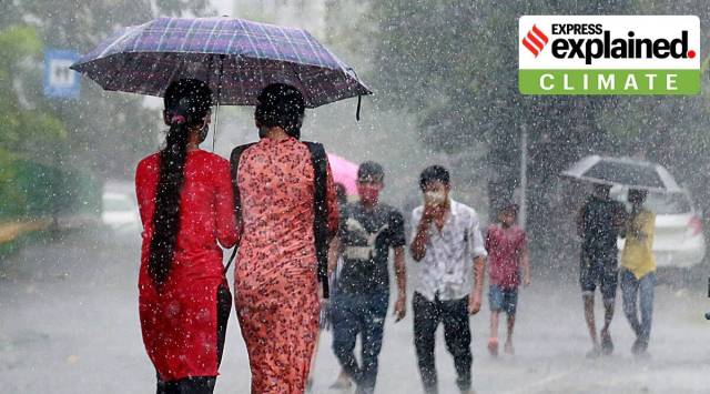
The southwest monsoon has started inconsistently in different parts of the country, with rain eluding many states but lashing parts of other states. The all-India rainfall was 18% short of normal until Friday. But while a majority of India awaits rain, Assam and Meghalaya have been submerged in record rainfall of 1,000mm in the last 24 hours.
Monsoon so far
Despite the monsoon’s early arrival on May 29 over Kerala, rainfall has been abysmally poor over most regions where the onset has been declared. The rainfall deficiency for the season until June 17 is as high as 60% in Kerala and Maharashtra.
Experts at the India Meteorological Department (IMD) said that the wind circulation pattern is yet to fully get established.
This, along with absence of favourable systems, have kept the monsoon inactive so far. Senior Met officials noted that the monsoon onset has largely been driven by convective activities — thunder, lightning and localised rainfall, mainly realised during afternoon hours.

On Friday, the Northern Limit of Monsoon (NLM) — or the imaginary line indicating the areas covered by the Southwest monsoon — passed through Porbandar, Bhavnagar, Khandwa, Gondia, Durg, Bhawanipura, Kalingapatnam, Malda and Motihari. On Friday, the monsoon advanced into a very small geographical area over north Bihar and sub-Himalayan West Bengal. The southwest monsoon has covered the entire Southern Peninsular and Northeast India, southern Chhattisgarh and Odisha, and some parts of Gujarat and Bihar.
Region-wise, the rainfall departures were –24% in Southern Peninsular India and +39% in East and Northeast India. Over other regions, where the monsoon is yet to arrive, the departures were –63% in Northwest India and –57% in Central India.
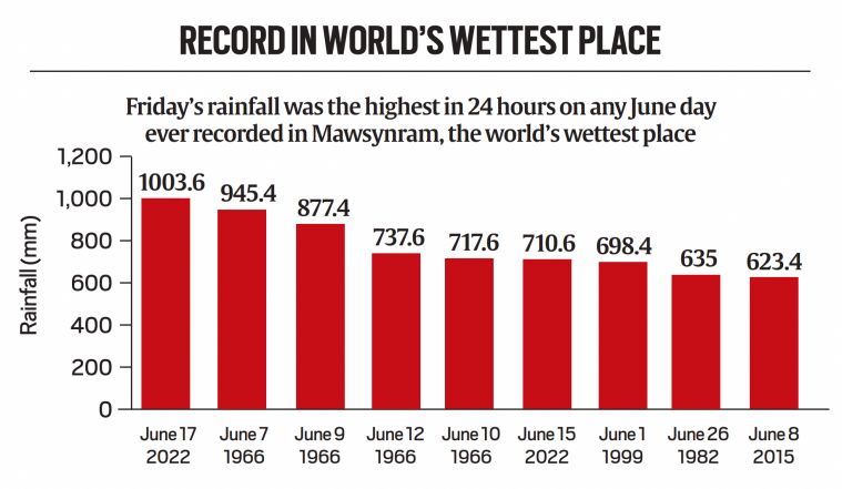 Record in world’s wettest place
World’s wettest places
Cherrapunji in Meghalaya, among the world’s wettest locations, has received unprecedented rainfall this week. In just three days between June 15 and 17, the total rainfall recorded was 2,456 mm — more than the annual rainfall of many places in central India and Mumbai’s seasonal (June to September) average rainfall. Friday (972 mm) was Cherrapunji’s third wettest June day since 1901, and Wednesday (811.6 mm) was the eighth wettest.
Mawsynram in Meghalaya, the world’s wettest place, broke an 83-year record for June. The 24-hour rainfall on Friday at Mawsynram was 1003.6mm. The previous highest rainfall in June here was 954.4mm in June 1966.
The IMD has attributed such extreme rainfall consistently over three days to the strong and moisture-loaded southerly winds blowing from the Bay of Bengal straight towards parts of Assam and Meghalaya. Since June 1, Meghalaya and Assam have recorded 194% and 96% surplus rainfall, respectively. Other northeastern states remain in deficit: Mizoram (–46%) , Manipur (–45%) and Tripura (–39%).
Implications for agriculture
Many southern states have started kharif sowing. At present, nursery sowing or transplantation of rice, finger millet, maize, soyabean, pigeon pea, groundnut are ongoing in Tamil Nadu, Kerala, coastal Karnataka, Andhra Pradesh, Telangana, Haryana and Punjab.
The agricultural meteorology division of the IMD has advised farmers to take up nursery of rice and vegetables and prepare land ahead of sowing.
Forecast
After remaining subdued for nearly three weeks, both the Arabian Sea and the Bay of Bengal branches of the southwest monsoon will make further progress starting June 19. The IMD has forecast enhanced rainfall activity along the west coast, especially Konkan, Kerala and coastal Karnataka during June 19-22.
“The monsoon winds from the Arabian Sea are set to strengthen, and there are chances of development of an off-shore trough parallel to the west coast, resulting in heavy rains along the west coast,” a senior IMD, Pune official said on Friday.
An “intense and very heavy rainfall” warning and a “yellow” alert have been issued for southern Konkan during these days.
The extremely heavy rainfall over the Northeast, especially Assam and Meghalaya, will continue until Monday. Thereafter, a reduction in rainfall is likely owing to the change in wind direction from southerly to westerlies from the Bay of Bengal.
Due to likely instability caused by interaction between westerly winds from higher altitudes and most winds from the Arabian Sea, Northwest India, parts of Jammu & Kashmir will receive heavy rain during the next three days, the IMD said.
With the monsoon still keeping with the normal onset dates and the current yet to be established, the upcoming spell starting June 19 still carries hope. According to officials, widespread and heavy rainfall can make up for the prevailing large deficits, and officials said conditions are favourable for further advance of the monsoon over Chhattisgarh, Odisha, Andhra Pradesh, West Bengal and Bihar by early next week.
Newsletter | Click to get the day’s best explainers in your inbox

What phase 1 voter turnout says about BJP’s chances inSubscriber Only

UPSC Essentials | Daily quiz: environment, geography, & moreSign In to read

Road ahead for Tesla: Why EV sector is strugglingSubscriber Only

Engineering in local language sees uptick in students in UP,Subscriber Only
How Bengaluru’s lakes disappearedSubscriber Only

India’s trade with Israel & Iran, and impact of regionalSubscriber Only

Acting is about convincing others, and the best actors can become anyone. Legendary actors like Mammootty, Kamal Haasan, Shah Rukh Khan have played versions of themselves, and now Nivin Pauly is attempting something similar in Varshangalkku Shesham. This takes courage and skill, but it can create a powerful and memorable performance.