
A raging river and frost-tipped dunes reveal watery history on Mars
Both NASA’s Perseverance and China’s Zhurong rovers have recently found signs that Mars may have had more water than expected.
Soaked sand dunes and rushing rivers once graced the surface of Mars, according to findings by two different rovers on the red planet.
China's Zhurong rover spotted evidence that frost may have cemented dunes together as recently as 400,000 years ago. And farther west, NASA's Perseverance found signs that a fast, powerful waterway once carved its way into Jezero crater, dumping water at a fantastic rate.
The crusty features on the dunes, first spotted in 2021, were recently described in a study published in Science Advances. Zhurong, which landed on Mars in May 2021, is currently dormant after failing to wake up following a planned hibernation period, likely due to the accumulation of dust on its solar panels.
The river that Perseverance spotted in a different area appears to be the largest ever found on Mars, more than 66 feet deep in some places based on the height of rock formations that scientists believe are preserved sandbars.
Both findings "highlight the fact that it's really valuable to put things on the surface of the other planets," says Jani Radebaugh, a researcher at Brigham Young University in Utah who is not involved with either mission. "We learn something new every time we do."
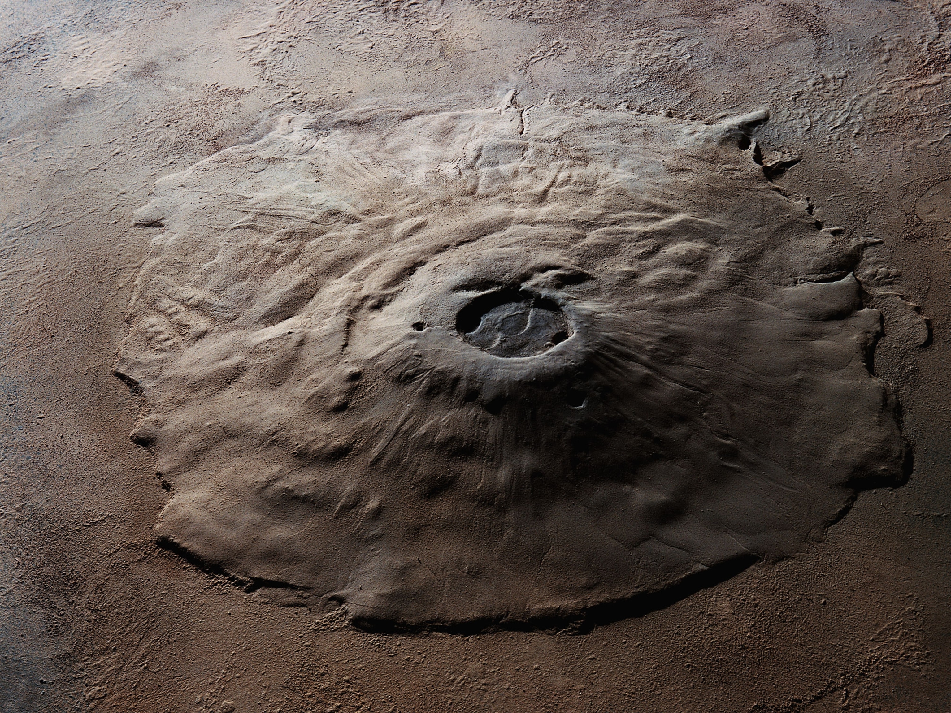
Frost on the dunetops
When China landed its Zhurong rover in Utopia Planetia, there were some questions in the Martian research community about the choice of landing site. While observations from space had led to theories that the region may have undergone flooding or even hosted an ocean, water-rich minerals evaded detection.
It didn't take long for Zhurong to prove itself. The rover almost immediately identified features suggestive of water near the surface, and researchers quickly reported hydrated minerals in the area. Evidence from the rover’s ground-penetrating radar also pointed to flash flooding in the area some three billion years ago.
Now Zhurong has found further signs of water on the Martian surface, and from a more recent time. Sand dunes near the rover have developed a crust that likely formed as water interacted with the minerals. That water could have come from frosts that formed on the dunes in the past, or it might have fallen as snow hundreds of thousands of years ago when the planet's tilt may have allowed for snowfall in this region. If frost or snow mixed with salts to lower its melting point, temperature changes on Mars could cause it to thaw.
The crusts have polygonal features whose cracks suggest they have shrunk and expanded repeatedly over time, “like mud cracks," says Radebaugh, who studies sand dunes. "To have these sort of shrinking and expanding features suggests there is relatively recent or modern or ongoing wetting and drying that's happening in these dune regions." Weather observations from the rover suggest that water vapor could create frost near the landing area even today.

Whether or not the water turned to liquid remains an open question, though. According to Ralph Milliken, a planetary scientist at Brown University and member of NASA's Mars Curiosity mission, the dust of Mars is enriched with minerals that can absorb water vapor from the air. If that material covers the sand dunes, humidity changes through the season could cause the dust to absorb water vapor and release it again without it ever becoming liquid.
But Radebaugh suspects that liquid water may have been needed to permeate the cracks in the features and make them expand. "You don't need a lot," she says. "You just need it to happen over and over again."
Similar crusts and polygonal features have been seen in other places on Mars but never on dunes, according to Radebaugh.
"These are likely things that are forming in lots of different places on Mars," Milliken says. "This might be a process that could be occurring over a large chunk of the planet in the recent geologic past."
The crusts also appear to be responsible for cementing the dunes into place. Martian dunes in other regions show signs of recent movement, but the dunes explored by Zhurong are frozen in time.
The rover has provided a new explanation for why the "dunes have stopped moving," says Xiaoguang Qin, a planetary scientist at the Chinese Academy of Sciences in Beijing who led the new research.
The Zhurong team used surrounding craters to estimate the age of the frozen dunes at between 0.4 to 1.5 million years, an eyeblink in geologic times. But not everyone is ready to accept such a recent date.


Regarding the young age, "I'm hyper-skeptical," says geologist Jack Mustard, also at Brown. He points out that dating using craters comes with a large margin of error.
Even without the craters, Radebaugh and Milliken suspect that the dunes are relatively young. Given enough time, wind erosion would scour the crust away, allowing the dunes to start moving again.
"These are definitely features that are much younger than any of the kind of rocks that are being explored by Perseverance today, or by the Curiosity rover over the past years," Milliken says.
A rushing river
While Zhurong investigated the repeated dune soakings, Perseverance explored the remains of a powerful torrent.
After an impact formed Jezero crater, scientists think water from the nearby valley networks flowed into the site to form a deep lake billions of years ago, when water still flowed across the surface. Percy is probing an area where water entered the lake, hunting for clues about how the liquid survived on the surface of what today is a dry, desiccated planet. Did the water slowly trickle in over millions of years, or did it flood in a single explosive burst?
Images captured by Perseverance in February and March provide evidence of at least one fast and furious flow. Giant stones, swept along by the river's water, were dropped in a series of curved bands, like arching rows of cobblestones deposited in the riverbed. The size of the stones hint at the raw power once exhibited as water rushed into the ancient crater lake.
"If you have meter-sized boulders, you're probably not moving those boulders with only an inch of water," Milliken says.

The flow was likely the strongest where the river met the lake, says Kathryn Stack Morgan, the deputy project scientist for NASA’s Perseverance rover, so it makes sense that larger rocks would be dropped there. As the river merged with the basin lake, it slowed, dropping smaller, finer particles farther out.
The region, newly named Skrinkle Haven after a beach in a British national park, has interested geologists for more than 15 years. Its bands of rock may be the remains of a common river feature: sandbars. These structures form as material flowing downstream piles up along the edges or in the middle.
These preserved sandbars can reveal a lot about how the river evolved over time. If the waterway meanders, the bars creep along with the changing banks. Faster flows push bars downstream over time, leaving a trace of the different paths cut by the water.
One of the most breathtaking examples revealed in the new images is Pinestand, a massive formation standing 66 feet high. A quarter mile deeper into the basin than Skrinkle Haven, Pinestand may represent an enormous deposit of sand and rock from the river. This six-story-tall structure would have been completely submerged.
Perseverance collected a sample from Skrinkle Haven to one day return to Earth for study.
Evidence of fast-moving water may not be a great sign for those hoping to find life at the site, however. "Those types of systems are not good for preserving evidence of organic material," Mustard says.
Nonetheless, the area has provided new information about the scale and dynamics of ancient Martian rivers.
"Jezero is kind of unique ... in terms of places where we actually have well-preserved evidence for the sediment accumulation as these rivers migrated," Stack Morgan says. "There are other places where we had systems like this, but I can't recall such a spectacular example as Jezero."
You May Also Like


Go Further
Animals
- This fungus turns cicadas into zombies who procreate—then dieThis fungus turns cicadas into zombies who procreate—then die
- How can we protect grizzlies from their biggest threat—trains?How can we protect grizzlies from their biggest threat—trains?
- This ‘saber-toothed’ salmon wasn’t quite what we thoughtThis ‘saber-toothed’ salmon wasn’t quite what we thought
- Why this rhino-zebra friendship makes perfect senseWhy this rhino-zebra friendship makes perfect sense
Environment
- Your favorite foods may not taste the same in the future. Here's why.Your favorite foods may not taste the same in the future. Here's why.
- Are the Great Lakes the key to solving America’s emissions conundrum?Are the Great Lakes the key to solving America’s emissions conundrum?
- The world’s historic sites face climate change. Can Petra lead the way?The world’s historic sites face climate change. Can Petra lead the way?
- This pristine piece of the Amazon shows nature’s resilienceThis pristine piece of the Amazon shows nature’s resilience
- 30 years of climate change transformed into haunting music30 years of climate change transformed into haunting music
History & Culture
- When treasure hunters find artifacts, who gets to keep them?When treasure hunters find artifacts, who gets to keep them?
- Meet the original members of the tortured poets departmentMeet the original members of the tortured poets department
- When America's first ladies brought séances to the White HouseWhen America's first ladies brought séances to the White House
- Gambling is everywhere now. When is that a problem?Gambling is everywhere now. When is that a problem?
Science
- Quieting your mind to meditate can be hard. Here’s how sound can help.Quieting your mind to meditate can be hard. Here’s how sound can help.
- Should you be concerned about bird flu in your milk?Should you be concerned about bird flu in your milk?
- Here's how astronomers found one of the rarest phenomenons in spaceHere's how astronomers found one of the rarest phenomenons in space
- Not an extrovert or introvert? There’s a word for that.Not an extrovert or introvert? There’s a word for that.
Travel
- Germany's iconic castle has been renovated. Here's how to see itGermany's iconic castle has been renovated. Here's how to see it
- This tomb diver was among the first to swim beneath a pyramidThis tomb diver was among the first to swim beneath a pyramid
- Food writer Dina Macki on Omani cuisine and Zanzibari flavoursFood writer Dina Macki on Omani cuisine and Zanzibari flavours
- How to see Mexico's Baja California beyond the beachesHow to see Mexico's Baja California beyond the beaches
